Generic selectors
Exact matches only
Search in title
Search in content
Post Type Selectors
Generic selectors
Exact matches only
Search in title
Search in content
Post Type Selectors

Last Chance Canyon

4 Reviews
Location Ridgecrest, CA
Rating Moderate,
Length 19.3mi
Time 4hrs

Vehicle Types

Overview

Challenging way to Bickel Camp and Burro Schmidt Tunnel.

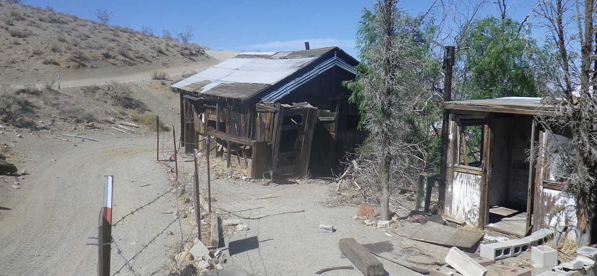
This alternate way to Bickel Camp and Burro Schmidt Tunnel offers a bit more challenge than Bonanza Gulch, Trail #55. Towering red buttes surround the canyon as you pass through Cudahy Camp and continue north. Don’t miss the interesting dugout west of the camp. Area is open to greensticker vehicles but you must stay on designated routes at all times. No camping in Red Rock Canyon State Park.

Rating

Moderate
Trail Ratings Defined

One spot, we call the V-slot, is very narrow and will challenge wider vehicles. A bypass is only slightly easier. Stock, high-clearance, 4x4 SUVs can manage this trail with an experienced driver. Be aware of the possibility of flash floods.

Stats

Length

19.3mi

Time

4hrs

High Point

4,120ft

Best Time To Go

Jan-Dec

Hot in summer.

Current Conditions

(661) 946-6092., (760) 384-5400.California State Parks, BLM, Ridgecrest F. Office

Check the Weather

No updates yet.

Provide an Update

Free GPS download

Trail Updates

11/01/2020
Submitted by Mirko
This trail was pretty badly washed out, making it borderline Difficult rather than Moderate. I only took the southern half, coming from Opal Pass (which was very easy by comparison). I had to cross from the broken trail to the wash at the bottom and back numerous times and stack stones to make it through some difficult spots with my Rubicon. I would only recommend this for vehicles with a significant lift and large (35+) tires in its current condition.

Reviews

Rate this trail on a scale of 1 to 5.


×

Kirk says

This trail wa a lot of fun! The cave / tunnel was what to be expected. The views were awesome!
×

Kirk says

My wife and I recently completed the Last Chance Canyon trail. It ended up at the burro schmidt tunnel. It is a 1/4 mile tunnel that was dug by hand over a 38 year period by one man; spectacular views!!! https://en.wikipedia.org/wiki/Burro_Schmidt_Tunnel
×

Mirko says

I recently completed the southern half of this trail, coming from trail 56 (Opal Canyon). While Opal Canyon was mostly easy, I would rate this trail as borderline difficult. The road was badly washed out and impassable in many places, so I had to drive through the wash instead, which had some very tricky sections with large rocks. By stacking rocks in a few places, I was able to make it through with my Rubicon, but I was on the verge of turning around a couple times... I would only recommend this trail to modified vehicles with large tires and a lift, and make sure to have a spotter with you.
×

Bob W says

On Trail 57 today (20Nov23) with my stock Rubicon on 33s. My experience much like Miko's post 3 years ago. Trail possibly still more beat up after last winter's storms. Turned around ~ 2.2 miles in. While probably passable, at ~2.0 miles it became not just rocky but fairly tedious with many scattered boulders requiring careful wheel placement. (And was by myself). "Difficult" might be a fair rating for this last stretch, I found it certainly more difficult (tho less steep) than the Trail 26 stretch rated "difficult" just before the crest of the Wheeler Ridge.
by Webolutions Digitial Marketing Agency


Cancel Agree